
-
Members of the previous forum can retrieve their temporary password here, (login and check your PM).
You are using an out of date browser. It may not display this or other websites correctly.
You should upgrade or use an alternative browser.
You should upgrade or use an alternative browser.
russian olive status ?
- Thread starter Felnik
- Start date
Migrated topic.
Dreammethodtool
Rising Star
This extraction may work well for this. Tons of it growing around here, I may be back. ")
Alcohol extraction of E. umbellata failed to fluoresce as well...I will be searching for local russian olive population after I move.
Great news!!!!!!!
I made a salt extraction of some russian olive bark material a few weeks back . Honestly i thought it was a failure.
What i ended up with was a nondescript looking grey powder that was scraped from a cloth filter.
I forgot it about it actually, today I remembered and noticed it in my kit bag.
Now i had tried it a few weeks back with rather dramatic results.
These results were inconclusive because i had had some caapi tincture along with this russian olive stuff. It could of been a few things that day so i wasn't sure if it was effective.
Today was nothing less than spectacular. I put some of this grey powder in the vape along with some mullein and a small amount of residual spice that was left in the bowl.
The results come on fast and almost instantaneous , all I can say is WOW ! it works.
The high is different than caapi leaves. Its much more energizing and clear. hard to explain but its amazing.
the place i got too once I really went for it was nothing less than nirvana.
The colors are Golden and reds.
It was like some kind of religious rebirth experience, i was in this golden loving crystal space. this is way beyond the dome, this is a deep spectacular zone. A total oneness with hyperspace.
The more love I put out to it the better it got. It lasted a long time just on one small hit.
The afterglow is beautiful I feel like a new person.
The ratio is interesting, this russian olive stuff seems to bump up a small amount of spice by an order of magnitude. There is some serious mojo in this russian olive stuff no doubt.
you will be impressed I promise.
This stuff needs to be looked into more.
I really want to hear about other peoples investigations into this.
love to all !!
This is amazing news! I take it you salted it out with the same above tek?
The ethanol extraction sounds like it worked for flouressence if this is the case evaping the menstrum would leave a crude extract like with caapi leaf that might be equally effective.
This needs to be explored furher. I wanna know if it will work as an oral caapi analog. This is so exciting!!!
How much leaf did you extract? I am wondering what the % of alkaloid is by weight of leaf.
zeroDorge said:How much leaf did you extract?
I'm investigating the alcohol leaf extraction that was in the picture, trying to evaporate down to a more concentrated form.
The thing i just wrote about is a salt extraction done from a large pot of russian olive bark. It was boiled for a few hours with vinegar.
it yielded a dark tea very reminicent of caapi tea. I performed a simple salting extraction where it was strained through a cloth.
Upon drying a brownish grey powderd was left on the filter material. this was scraped off and collected.
Now i'm sure a further wash could be performed for a more pure product. i did not do this.
I'm very surprised this has never been explored . i would like some other people to investigate this and see if i'm not crazy .
when vaped the experience is amazing clear and very energetic. I was in hyperspace with only a very small amount of spice.
the experience was bright and nothing less than nirvana.
Its really really good .
Ah ok you used bark. I've never salted out harmalas, pm your tek will ya?
I am curious about the leaves... They did glow. I would just put the ethanol extract in a rice cooker with some mullien or some smoking material and try it.
This is really awesome!
I am curious about the leaves... They did glow. I would just put the ethanol extract in a rice cooker with some mullien or some smoking material and try it.
This is really awesome!
Very interesting!
Do you have a rough estimate on the yield?
Do you have a rough estimate on the yield?
The yield was a small amount I didn't measure it ,
I will do a more careful
Extraction with accurate measurements . I,m on it for sure .
The good thing is this tree grows everywhere .
And apparently a little dab will do ya .
I will do a more careful
Extraction with accurate measurements . I,m on it for sure .
The good thing is this tree grows everywhere .
And apparently a little dab will do ya .
Could this mean it is another kind of harmala instead of the usual ones. One that is stronger that harmaline/harmine/THH?Felnik said:And apparently a little dab will do ya .
Dagger said:Could this mean it is another kind of harmala instead of the usual ones. One that is stronger that harmaline/harmine/THH?Felnik said:And apparently a little dab will do ya .
Thats right!
The bark was fresh or dried ?
Bark from what part of the plant: trunk ( high or low ?), branches ( small or big? ):?:
How many doses per raw weight of plant material you could estimate ?
Very interesting ! Thank you very much for this bioassay.
This plant has to be all around in the wild here in my region too.
It fixes his own nitrogen so is able to grow in harsh soil, then helping other plants to survive.
From millennia R. Olive trees are doing their job, waiting the discovery of the secret wisdom they have to share.
I believe his reputation as the aya-ally of choice for many westerners will be soon increased,
recovering the relationship among territory and plant teachers that we lacks.
I'm also very interested in this new teacher. Do they grow in America, particularly the South East around Florida?
I'd love to start cultivating some.
I'd love to start cultivating some.
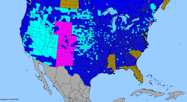
A distribution map for the lower 48 US states (at the county level) for E. angustifolia is attached. Counties that are light blue (aquamarine?) or purple are confirmed occurrences by various botanical sources. Light blue indicates present, purple indicates noxious (but this is more a political, rather than scientific distinction). Counties that are dark blue are merely reflecting in-state occurrence, but not in that county.
The actual image size is larger than the attachment appears, but you should be able to save the map to view the larger size (I believe).
EDIT: A brief note...while the info mapped is rather comprehensive, it is lacking inputs from 2-3 serious botanical journals (but contains the data from 100s of others) which are in the process of being added. With this in mind, there is the potential for it to occur in counties not marked, but generally, it can be fairly safely assumed that such counties would be close to or fall within the general distribution created by the mapped counties.
Attachments
Thanks for the info Snozz...
I guess it doesn't look like I'll be finding any locally here. If I find a vendor for seeds, I'll report back.
I guess it doesn't look like I'll be finding any locally here. If I find a vendor for seeds, I'll report back.
Similar threads
- Replies
- 6
- Views
- 159
- Replies
- 6
- Views
- 410